Sunday, August 28, 2011

#17 Lewall Inlet, Frypan Bay, Sullivan Bay, Turnbull Cove and Port McNeill.

Tuesday, August 23, 2011: Lewall Inlet, a Pruth Wifi stop, to Frypan Bay

Although still gloomy, the rain has stopped.  Today we will follow the Maritime to Pruth Bay on Calvert Island.  Rob and Donna want to visit the Hakai Institute.  The Wild Blue crew wants to use the Institute's open wifi signal to get the email.  It's about 5 miles from Lewall Inlet just across the Hakai Passage.

Once there, we hover near the wifi signal and later leave Maritime anchored.  We learn from email that our friends on Z-Worthy, another Selene, were behind us in Shearwater two days ago.  So today they should be close if they haven't already passed us.  We'll keep a lookout for them.

Once out in Fitz Hugh Sound going south, we give the Z-Worthy a call on the VHF. No answer.

We want to end the day in a secure anchorage near Rivers Inlet such that we will be about 4 hours or so from Cape Caution. We need to cross Queen Charlotte Sound which is an exposed ocean run. The nearest anchorage probably is Fury Cove on Penrose Island however it is exposed to southerly winds.  We decide upon one of the Frypan anchorages: either Big Frypan or Frypan.  The names probably come from their shape.  Like Alaska, these anchorages have a handle which is a narrow entrance.  The bays are round, much like a frying pan. Frypan is more popular because it is not a deep anchorage.

We arrived at Frypan and anchored as the lone boat then took the tender out exploring local lagoons.  Back in the Bay, the Grocery Boy of Anacortes had anchored.  This charter boat goes to Alaska each year.  We visited on the Grocery Boy and talked about the fishing.  THat day Rivers Inlet had yielded them multiple salmon and a huge halibut.  The charter crew was quite happy.  They will fish again tomorrow.  We plan to round Cape Caution.

By 6PM about 7 boats had anchored inside "our" bay. Thirty minutes later we hear "Wild Blue, Wild Blue, this is Z-Worthy" calling on the VHF.  Seems they found us via AIS and were heading for Frypan.  We invited them to side-tie to Wild Blue and to join us for dinner.  Ron and Bonny told scary stories of high winds and nasty seas on their run down northern British Columbia.  They seemed too happy to be in a quiet anchorage.

 
Entering Frypan Bay


Lagoon has it's own ecosystem.

Bill examines this lagoon's flora and fawna.

Wednesday, August 24, 2011: Frypan Bay, Cape Caution to Sullivan Bay

Any Cape Caution rounding starts with the 4AM BC Marine Forecast for Queen Charlotte Sound.  Information on the current conditions at the West Sea Otter Buoy and Egg Island Lighthouse is also desirable.  Alex monitored the weather broadcast.  Our rule of thumb for rounding is: "a Queen Charlotte Sound wind forecast less than 20 knots and a sea condition report at West Sea Otter Buoy less than 1 meter". The seas were already 2 meters at 5AM but the Egg Island Lighthouse reported "Seas rippled with a low northwesterly swell".  So at first light, the crew detached Z-Worthy from her side-tie, secured the tender to the boat deck, raised the anchor, and headed south into the Sound.  The winds were less than 10 knots but the seas occasionally reached 2 meters (6 feet). Thankfully these larger seas were well-spaced apart so that the rolling motion was mostly dampened by the boats active stabilizer fins.

We took the inside route, just off the coastline, threading our way between the many rocks and reefs that litter the Cape area, but that also provide smoother seas close off the beach.  We stayed behind Egg and Table Islands with good sea conditions.  Z-Worthy and another yacht followed close behind.  By 10AM we rounded Cape Caution as the winds and seas slowly decreased to nothing, and a fog enveloped the boats.  We passed a few northbound boats within 1/4 mile without seeing them but the radar and AIS allowed us to pass without collisions.  We turned into Wells Passage as the fog lifted and tied to the dock at Sullivan Bay around 2PM in front of Three Wishes another Selene 53.  Neil and Nancy invited the crews to a dinner of Greek fair at the floating town's restaurant. The sun came out near the end of the day.

Selenes line the Sullivan Bay Dock: Z-Worthy, Wild Blue, and Three Wishes.

Our first sunset with real sunlight in 5 days!

Thursday, August 25, 2011:  Sullivan Bay to Turnbull Cove

Only 40 minutes away, Turnbull Cove is a great place to enjoy the sunshine.  Along the way we dropped the prawn traps in 280 feet outside the entrance.  Inside the cove we started the crab traps soaking too.  Soon after anchoring and side-tying with Z-Worthy, we visited the Nepah Lagoon.  The entrance to this 4-mile by 1/2 mile body of water is restricted to 3 feet at low water and is only 50 feet wide so that the current races by at 10 knots, unless you enter at slack.  We did so about 30 minutes after slack and the dinghy needed an engine RPM boast.  The lagoon is BIG.  We motored to the end searching for salmon rivers.  Great scenery gave way to the need to exit before the entrance rapids escalated.  Upon exit the water fell like a water fall, albeit only a tiny one.  We squirted out without incident.

Approaching Turnbull Cove

It's Karen's birthday.  No worries, her young age will not be divulged.  Tonight's dining venue is on the cleared boat deck of the Wild Blue in brilliant sunshine.  The menu is impressive:

Karen's Birthday Epicurean Dinner
Happy Hour: Wiser's Whiskey cocktails with Z-Worthy's fresh sushi
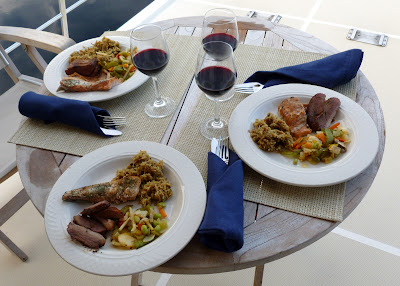
Main Course: Wild White King and Coho Salmon bbq'd on cedar plank, Willie-Bird bbq'd duck breast, wild rice and vegetable medley
Wine:  2004 Opus One
Dessert: Homemade Key Lime pie with fresh-whipped cream.


At last summer has arrived in the Pacific Northwest!


Dining at Wild Blue Skylounge.

Wild Cedar Plank Salmon and BBQ duck breast.

Bonny, Pat and Karen.

Happy Birthday Karen.


Friday, August 26, 2011:  Turnbull Cove to Port McNeill

Port McNeill is the destination of choice for exchanging crew. Lately we secure moorage at the Port McNeill Fuel Dock and Marina as opposed to the city run dock.  Besides great accommodation and 50-amp power, they provide free use of a van for picking up or dropping off crew at the Port Hardy Airport.  

It's a short 3-hour tour of Wells Passage and Queen Charlotte Strait to get to McNeill.  The water was flat calm and the Strait displayed little wind.  You could see small groups of Dall's Porpoise breaking the surface more than a mile away.  As we approached Ledge Point just outside McNeill, many sports-fishers were trolling close ashore. Later we learned that the Coho and Silver Salmon are biting big-time in the early mornings.

On the dock we see the a pretty green Selene 53 named Chatham II.  Vera and Len are Canadians who have been cruising BC waters all their lives on sailboats and the last several years on their Selene.  They have a cool fireplace inside their saloon.  We'll be sure to join them to swap a few sea stories.

Karen and Bill, the Wild Blue crew this past week or so, leave for San Luis Obispo tomorrow.  It's been a fun time with the easy going Almas'.  Monday a new crew arrives.  Pat and Alex will take a few days to wind down.

Evviva arrives in Port McNeill.  This 160-foot Westport super-yacht is owned by the guy that built 4000 Bayliner Yachts for years and then sold out to Brunswick Corp.  Later he re-entered the boat building business with Westport yachts an "economically priced" super-yacht line.  This one sells for an economy minded $30 million.  Contrary to the video narrator, we didn't get an invite to dinner aboard Evviva.


Saturday, August 27, 2011

#16 Bella Coola, Namu to Lewall Inlet

Sunday, August 21, 2011: Bella Coola to Rocky Inlet (Namu)

Rain and southeast winds are predicted today.  The Wild Blue and Maritime will slowly cruise westward, down Burke Channel, towards the building winds and rain.  There are several places to duck into if it gets nasty including: Cathredral Point anchorage, Fougner Bay, Namu or Rocky Inlet behind Namu.  So off we go examining the various creeks and rivers, which because of the heavy rains, are all flowing like big rivers.  We are looking for salmon amassing near these water mouths.

Maritime holds her course.

We fish our way along and all goes well, for the weather, but not the fishing.  At Cathedral Point, about 30 miles southwest of Bella Coola, winds are light, rain is heavy and we continue. 20 miles later, the winds are building with gusts over 20 knots so we decide on Fougner Bay.  This Bay is small but nicely preotected and upon close inspection, we find two boats already anchored there.  We continue and as we turn left into Fitz Hugh sound, the winds are gusting in the upper 20's and the seas are punchy.  The Namu dock looks to be too exposed to these southerly winds, so we sneak back into Rock Inlet, just behind Namu and anchor in calm waters with a few other boats.  It's a good place to be as the winds are less than 10 knots.

Wild Blue battles the building seas and driving rain. (Rob Bonner photo)

Namu was once a busy fish canning town.  The killer whale that was caught in a fisherman's net near the town assumed it's name.  Namu now  serves as a overnight spot for visiting pleasure craft.

Entering Rock Inlet

Rock Inlet after the wind dies.  The top is live, the bottom is a reflection.

This is not a  Rorschach  diagram.

Pat's homemade tabbouleh, Karen's Teryaki salmon, and seasoned potatoes made us forget the rainy weather..

Monday, August 22, 2011: Rocky Inlet to Lewall Inlet

The storm has passed and just spotty light rain remains.  Today we'll cross Fitz Hugh "Sound", which really seems more like a "Strait".  On the way we'll fish just outside Namu, then the Nalau Pass area.  The plan is to stay inside well-protected Lewall Inlet for the night, just in case.

Our Route for the next few days.

Exiting Rock Inlet

The ocean is quite calm and once trolling, it's easy to see our flashers down to 20 feet deep.  We troll at 35 and 50 feet using Apex lures: Alex's shiny bright Hot Shot, and Bill's dull green Apex.  It's a dull green kind of day and Bill begins landing fish.  A small King, a big Coho, another King, all this as Alex watches.  Finally the skipper gets a bite and lands a King, but it didn't have the fight to detach from the down-rigger! Oh well.

After a short day of cruising-fishing, we squeeze through the narrow entrance to Lewall Inlet on Stirling Island and anchor for the night.  We invited Rob and Donna for dinner aboard, and Donna brought some yummy crab artichoke dip.   We served Pat's homemade meatballs with Karen's tasty Italian sauce over linguine.   All crew survived a dessert of homemade brownies and ice cream.  We slept good!

Veteran Wild Blue crew Bill Almas shows how easily it is to catch a salmon.  This Coho is around 30 inches or so.


Today's haul off Namu and inside Nalau Pass area after 90 minutes of trolling.  Bill caught three fish and chopped the head off Alex's fish.  Note how small Alex's fish looks.

Entering Lewall Inlet on Stirling Island

Sunday, August 21, 2011

#15 Shearwater, Ocean Falls, Eucott Bay and Bella Coola

Thursday, August 18, 2011:  Shearwater to Ocean Falls Again

Our new crew jumped off the Bella Bella water taxi just after noon.  We grabbed a lunch at the Shearwater resort restaurant then got a BC fishing license for the crew.  We were off the docks by 2PM on the way to Ocean Falls.  The "drinking" water at Shearwater resort has always been marginal with its diluted Wisers whiskey color.  On the flip side, Ocean Falls water is the tastiest water we've ever drank and feels supersoft in the shower.  It was an easy motor to the "Town of the Rain People"under sunny skies for a change.  Ocean Falls receives the second most rainfall per year of any city in all of Canada, something like 158 inches per year, so it was unusual to see the sun out when we arrived.

Our Route over the next 5 days.


On the way to the dock we dropped a couple crab traps to soak, just in front of the spillway form the large dam that forms Link Lake behind and above Ocean Falls.  Then we tied up and the city run dock and rendezvoused with Rob and Donna on the Selene 47 "Maritime".  Maritime is also cruising south from Alaska taking it slow and easy.  Looks like we make hang with them for part of our trip.

Once tied up, the Almas', our new Wild Blue crew for a week or so, wanted to tour the town.  Bill and Karen are friends from San Luis Obispo.  Bill is with Chevron and Karen is a zoologist.  They've been aboard for many previous voyages and are a bunch of fun for various reasons. Among them: Karen's great chefing talent, and her nature to examine in detail any plant or animal we happen to run across.  For example when we catch a fish, Karen is ready to dissect it and examine its stomach contents.

We walk the town then return for happy hour.  Besides Rob and Donna, we ask another cruiser couple Rick and Ann from Kandu to join us.  Rick grew up in Ocean Falls from 1956 to the mid-1960's.  He lived there in the 3,900 people town's heyday of logging, Crown Zellerbach paper mill and cruise ship tourism.  Rick has some compelling stories about Ocean Falls.  We learned the when built, the local hotel was the second largest in British Columbia.

Dam behind and above Ocean Falls forms Link Lake.

Spillway adjacent to town.

Friday, August 19, 2011: Ocean Falls to Eucott Bay

We pulled our crab traps and were pleasantly surprised to find 4 keeper crabs.  We then set our course for Eucott Bay.  The Bay provides excellent shelter as BC Weather is forecasting a 40-gale over the next sevral days so it's best to be prepared.  We might actually get a storm this time!

One the way we stop to fish Rattanbury Point near the entrance to Cousins Inlet.  The Ocean Falls locals tell us Coho salmon are there.  We set out two salmon trolls, one with a herring bait, the other with Alex's lucky Apex Hot Shot lure.  After about 40 minutes with two hits on the bait, a good sized Coho takes the lure and Bill and Alex land it.  Then we motor on to Eucott Bay while crab and fish are cleaned, cooked and/or processed for the freezer.

Along the way we stop at the Alexander MacKenzie Monument.  MacKenzie was an explorer who searched for the Northwest Passage by land.  He was the first person to cross North America north of Mexico in 1793, just missing Captain George Vancouver by six weeks. The Monument records where Alex left a sign on the rock that reads  "Alex MacKenzie / from Canada / by land / 22d July 1793" using a reddish paint made of vermilion and bear grease. We saw the rock and markings just below the Monument on the north side of Dean Channel.
Alexander MacKenzie Monument.  Alex was the first man to cross North America above Mexico in 1797.

Alex left this message for Captain Vancouver. Originally written in "bear grease" the rock has been engraved to memorialize the feat.


Eucott Bay turns out to be a fine place:  it's shallow with lots of room for many boats;  it's flat calm;  it has a hot springs with easy access that does not stink of sulfur;  and the the views remind one of Yosemite with a half-dome look-a-like.


Crab from Ocean Falls.

Karen is a happy crew and crab picker.

Processing the catch.

Maritime at anchor in Eucott Bay

Donna, Rob, Bill and Alex enjoy Eucott Hot Springs

Saturday, August 20, 2011: Eucott Bay to Bella Coola

Bella Coola is probably one of the largest communities in the area.  It's only about a 3-hour cruise from Eucott.  It looks like a fun place to explore. But before we can leave Karen scratches out a delicious crab scramble.  Along the way we enjoy tasty crab cakes and excellent vistas in glacier colored waters.  Life is rough on the ocean!
The fare: Karen crab scramble.

The View: BC Inland Coastal Waters


Karen's crab cake.

 We made it to Bella Coola, about 50 miles inland from the coast.  We're tied to the dock.   It's raining hard and the wind is blowing only about 20 knots so far.  High winds and heavy rains are predicted for the next day or so.  Tomorrow, we'll head southwest towards Fitz Hugh Sound and into the yukky weather.


Wednesday, August 17, 2011

#14 Penn Bay, Klemtu, Rescue Bay, Wigham Bay, Beales Bay and Shearwater

Sunday, August 14, 2011: Penn Bay, Meyers Narrows, Klemtu, Jackson Passage, Jackson Narrows to Rescue Bay.

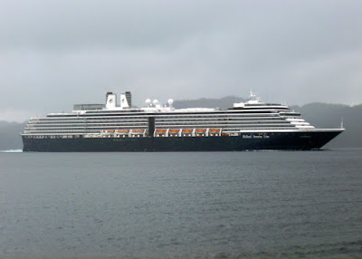
We left pretty Penn Bay at 9AM to insure we arrived at Meyers Narrows at high slack tide.  The narrows is only 4 foot deep at low water.  Today the prediction is a plus 14-foot tide so we should see around 18 feet minimum depth at 2:30PM.  We putt south westward down Surf Inlet and merge into Laredo Channel.  It's raining with about 3-mile visibility.  The AIS shows 4 commercial tug and cargo ships within range as well as the Voldendam, a 900-foot Holland-America cruise ship.  This year we've noticed these ships cruising the interior waters of the Inside Passage. Passengers get a “close up and personal” view of the passage and are guaranteed flat calm waters while inside. The BIG ship glides past us within ¼ mile doing 23 knots. We activate the stabilizers to keep the dishes in their cupboards.

The Voldendam

Route from Penn Bay to Rescue Bay

Then we cross rocky Laredo Sound to Meyers Passage, and things level out again.  We switch off the stabilizers and prepare for skinny Meyers Narrows.  All is well and make a U-Turn over the top of Spit Head and turn south into Tolmie Channel.  After a couple miles we stop in front of the Boat Bluff lighthouse.  The Boat Bluff lightkeepers usually leave their wifi open for passing boaters.  In 2009 we shaw 20 boats or so stopped here and thought it was a big salmon run.  It turned out to be a big wifi run!  Today their wifi is off, so we head down a few more miles to Klemtu, the Indian tribal council village.  The Klemtu dock is full but McKnight's wifi is open, so we loiter in the harbor downloading our emails.  After checking Google News we motor on down through Jackson Passage and find the fish farm wifi open.  Again we loiter while answering our emails.  Finally we squish out east through Jackson Narrows and anchor in nearby Rescue Bay.  What a day!

Navigating Meyers Narrows

Cruising by the Boat Bluff Light Station

Rainbow waiting for us in Rescue Bay

Monday, August 15, 2011:  Rescue Bay to Wigham Bay

It's a short run to Wigham near Bella Bella, another Indian village town. We want to be near Bella Bella for cell service as Pat wants to check on her mom.  We hope Wigham is close enough.

Wigham is another pretty spot.  We anchor in a private little bay inside.  There are two other boats, each in their private bay inside Wigham Bay.  It's cool!  Wild Blue becomes the center of a huge bait ball, with thousands of herring circling around her.  But no bigger fish came around, perhaps scared away by the large underwater profile of the looming hull.

Pat makes her calls and all is well.


This is NOT the logo for Canadian Target Stores.


Tuesday, August 16, 2011:  Wigham to Beales Bay

Beales is another bay close to Bella Bella's cell service.  By the way, no AT&T service here, just Verizon. We anchor again under the threat of yet more high wind forecast.  I'm sure there's big winds somewhere, just not here.
Peering into Beales Bay Lagoon

Tomorrow we will take to the dock at nearby Shearwater Resort to gather crew arriving Thursday at the local airport.  Then its off to that ghost town of Ocean Falls yet again for their tasty super-soft water.  We'll be out of touch for several days as we move down the BC Coast crossing Queen Charlotte Sound into the protected waters inside Vancouver Island, arriving there around August 26th or so. Chow!

Saturday, August 13, 2011

#13 Prince Rupert, Pillsbury Bay, Hunt Inlet, Baker Inlet, Lowe Inlet, Chapple Inlet, to Penn Bay

Monday, August 8, 2011: Pillsbury Cove in Prince Rupert

We had planned to stay at least two nights, but after a rocky evening tied to the bouncy docks at Prince Rupert Rowing and Yacht Club, we were ready to move. PRRYC is exposed to passing boats on their way to and from one of several marinas in Prince Rupert Harbor.  Unlike most harbors, PR does not have a speed limit so the Yacht Club docks are continually subjected to large boat wakes.  There's really no advantage to staying at these docks as the power is marginal.  Our 30-amp circuit kept tripping the breaker at 20 amps.  The only reasons to moor here is for good fresh water and shoreside business access, otherwise it's not worth the $100 US per night, in our opinion.

Even though there was plenty of empty dock space, it took some yakking with the PRRYC harbormaster to allow us to stay 60 minutes beyond the 10:30AM checkout.  We raced to the town's Safeway and did our final provisioning for 20+ days and made it back to the boat, avoiding an additional $5 per hour charge.  We then pulled away for our next destination, Pillsbury Cove just 3 miles across the Prince Harbor.  Here the waters are calm and we enjoyed a peaceful afternoon.  The Canadian Coast Guard Ship Arrow Point also joined us in Pillsbury Cove.   Later we launched the tender and took a cruise to town so Alex could mail in his ballot back to SLO town. That night the waters continued their calmness and we slept soundly, all for a great price!
Our Route across Prince Rupert Harbour to Pillsbury Cove

Canadian Coast Guard Neighbor in Pillsbury Coce

Tuesday, August 9th, 2011: Pillsbury Cove, Kinahan Islands, Hunt Inlet

We've already crossed the Dixon Entrance so we have extra weather days to spare and decide to visit on a local anchorage, just 15 miles south of Prince Rupert.  The commercial fishing fleet is arriving as we exit the Harbor.  We plan on Lawson Harbor which should be in cell phone range so Pat can stay in contact with her mom as she recovers form health issues.  Later the evening forecast calls for strong winds so we opt for Hunt Inlet on the northern edge of Porcher Island, in the same vicinity as Lawson Harbor.  Hunt provides excellent protection 1.5 miles deep inside it's shallow waters.  But for now the winds are light and seas are flat.  We stop the boat and rig for salmon trolling near the Kinahan Islands along our route.  After 90 minutes without a bite, we anchor inside the Island for lunch.

The Route from Prince Rupert to Hunt Inlet

Later we head for the Inlet arriving in the late afternoon and note the several homes that line the coast.  We want to anchor deep inside but a narrow channel with just 7-foot depth keeps us pondering.  Finally we add our 9-foot plus tide and line up in the passage.  It's an uneventful entry into the Inlet's inner sanctum.  We drop anchor in the flat calm waters, ready for any big wind.

Hunt Inlet Anchorage


Hunt Inlet Neighbors

Wednesday, August 10th, 2011: Hunt Inlet to Baker Inlet

We awoke this morning debating routes south:  inside versus outside.  The outside route offers many remote anchorages we haven't yet visited, but the inside route down well-traveled Grenville Channel offers us Hartley Bay's cell phone coverage by tomorrow.  Alex has a meeting Thursday at 1PM which he plans to attend via tele-conference.  Only lack of cell phone or internet access prevent him.  The native village of Hartley Bay has cell, so the inside route it will be, with tonight's stop at Baker Inlet.  It's an easy motor in flat seas amongst the commercial seiners working their nets across the top of Porcher Island. We pass Lawson Harbor then notice two police boats, a Coast Guard Ship, helicopter and a Canadian warship intermingling with about 10 commercial fishing boats.  Not sure what the beef was as we minded our own business.  Let's hope it was some kind of joint exercise?

Canadian Warship #709 cruising up Grenville Channel

After 10 miles of cruising into Grenville Channel we arrive at Watts Narrows, the skinny entrance into Baker Inlet.  We've timed our arrival for slack current at 1PM.  Next we point Wild Blue east into the Narrows, announce a Securite call over the VHF to alert any outbound boats and begin our entry.  All is well except our GPS plotter has the boat out of Watts Narrows, off course, running over land!  This occasionally happens when the GPS signal is blocked by high mountains, so occasionally, even we computer geek captains have to use our eyeballs.

Watts Narrows Route


Baker Inlet Route

Once inside we maneuver to a spot about 275 feet deep and launch two prawn traps.  We'll soak them overnight and see what shows up tomorrow.  We anchor at the head of Baker Inlet, alone amongst the cedars, spruce and hemlocks.  It's a pretty site.


The Wild Blue at anchor in Baker.

Thursday, August 11, 2011: Baker Inlet to Lowe Inlet

Alex needs to get Hartley Bay cell service by 1PM.  He's up early gathering the prawns traps then loading the dinghy on to the boat deck.  Finally we're off at 7AM.  It's a 5+ hour motor south down Grenville channel.  We've moving along OK with a good chance of making it when the current reverses.  Suddenly instead of 9 knots, we're making just 6 knots.  We realize Alex will miss his tele-conference by an hour.  Oh well, we can always reschedule, and we pull into Lowe Inlet to wait out the adverse current.

We passed 5 Wave Runners traveling north at high speed.  It took 8 exposures to get one with a subject in it.

Lowe Inlet


There are three other cruising boats waiting as well and after a couple hours the Inlet is boat free, as the others continue their journey.  No longer in a hurry, we reset the anchor at the foot of Verney Falls at the head of the inlet and begin watching many huge salmon jumping up the falls, some into the mouth of a large black bear.  Soon a sportsfishing boat arrives, motors inside the 'no fishing zone” at the base of the falls, and starts reeling in huge salmon after salmon.  Alex spies the ubiquitous “Buzz Bomb” fishing lure on the fisherman's pole, and begins to gear up!

Anchored in front of Verney Falls

With the tender launched, Alex packs the “Buzz Bomb” and “Apex Hot Shot” lures, pole and net, as well as other essential salmon handling gear (fillet knife and rubber mallet).  He positions the tender outside the “no fishing zone” but where many salmon are repeatedly leaping from the liquid.  He does not have a good casting pole but manages to fling the weighted “Bomb” far enough to get a short troll.  The Bomb's weight takes it deep, under the many huge salmon lingering near the surface.  After numerous casts without bite, he switches to the “Hot Shot”. This lure is light and stays near the surface.  It has great action and can be seen for a good distance.  It's lightness makes it too difficult to cast with the stiff fishing pole, so Alex devises his own “motor casting” technique.   As the tender is motored across the salmon zone for 100 yards or so, occasional line tension is applied to keep the lure near the surface.  The boat is stopped and the lure slowly reeled in. Bingo! A huge salmon attacks the lure and cleanly breaches the surface some 50 yards away.  The fight is on and after a few minutes the big beast is alongside.  It takes a bit of learning to land  big salmon singlehandedly, but after losing one, the second is hooked on the next troll.  Within 40 minutes three out of five hookups are in the box.  These Coho salmon range from 30” to 36”.  One thing is for sure: salmon fishing is a hoot!


Verney Falls at high tide with sports fisher inside the "No Fishing Zone"

The ubiquitous Buzz Bomb lure.

 The Apex Hot Shot did it's job!

This 30-incher was the smallest of the three fish.

 Pat is dreaming about salmon dinners.


 Pat's fresh tomato, garlic and mushroom pasta sauce


Fresh Baker Inlet prawns with Orecchiette del prete in Pat's pasta sauce.

Back at the Wild Blue the fish cleaning process begins.  Having never cleaned and filleted a salmon before, Alex learns it takes a bit to become any good at this.  But after hacking away for longer than it took to land the fish, and spewing fish guts and blood here and there, Alex is able to create some 15+ pounds of salmon fillets.  Pat says she is impressed and adds “Now clean up the boat!”  She retreats to the salon for shrink wrapping and deep freezing, exclaiming “Fresh prawn pasta tonight, and fresh salmon tomorrow”. Okay!

Friday, August 12, 2011: Lowe Inlet, Hartley Bay, to Chapple Inlet

We're on our way to Hartley Bay by 10AM. A large BC Ferry passes up in the Grenville Channel, requiring us to move a bit so the big ship can pass.  We get to Hartley Bay by 1PM, feast on cell service and fill our fresh water tanks.  Then it's off to a secure anchorage for the night as 30-knot southeast winds are forecast for early tomorrow AM.

Route from Lowe Inlet, to Hartley Bay, to Chapple Inlet.


Wild Blue moves over for BC Ferry.

We're back on the outside route passing Gil Island, very near the site of the 2006 sinking of the BC Ferry “Queen of the North”.  The villagers of Hartley Bay were the heroes who rescued 99 passengers and crew after mid-night on that fateful March evening.  Wiki “Queen of the North” for the latest theory on why the ship ran into Gil Island.

We cruise down Campania Sound under gloomy skies and light rain.   We're open to ocean swells but there are none.  A good anchor spot is Emily Carr Cove but the tide is too low for us to enter.  Chapple Inlet is described by the guide books as a “bombproof” anchorage so we wind our way up the 3-mile inlet, squeezing through two shallow narrows to keep our hearts a pumping.  Finally we drop anchor at the Inlet's head in 40-feet, with 5 to 1 rode, and set the depth and drag anchor alarms.  The rain intensifies but so does our appetite as we savor fresh salmon fillets, grilled to perfection. Yum!

Exiting Chapple Inlet is exciting!

Saturday, August 13, 2011: Chapple Inlet to Penn Bay

This morning the big breeze has been pushed back until late morning, another typical outcome for BC weather prediction.  The wind in Chapple Inlet hasn't surpassed 12 knots but outside reports winds in 25+ range.  We delay our departure for another reason: we want high water to sooth frazzled nerves when re-crossing those shallow narrows. Finally at 2PM we start the engine for a 90-minute run up Surf Inlet to Penn Bay.

Penn Bay is the only real anchorage in Surf Inlet.  It's protected on all sides and has a deep water entrance, something we seem to like lately.  We may visit the abandoned hydro-electric plant at the head of the Inlet as well, if the sun comes out.


Penn Bay turns out to be awesome with multiple creeks and a racing low waterfall at it's head.  Outside the cabin house, the aroma of fresh trees fill the air. Hemlocks and fir smells remind you of a Christmas tree lot. The wind never exceeds 5 knots but it continues to rain lightly. Pat says put Penn Bay on our highly recommend list, so we will!  Best to view the video and photo and make up your own mind.

The Penn Bay Waterfall


Tomorrow we will run down Surf Inlet, south along Laredo Channel, into Myers Passage, arriving at Meyers Narrows at 2PM high tide and slack current, then on to Klemtu for the evening.  We hope to have wifi to get these updates to the Blog.  See you there.