Wednesday, September 14, 2011

#19 Princess Louisa To Anacortes, WA and the end of our 2011 Alaska Cruise

Saturday, September 3rd, 2011 - PLI to Secret Cove


Today we left Princess Louisa Inlet on the way to Secret Cove on BC's Sunshine Coast.  Unfortunately, Alex made two mistakes today.  The first was a miscalculation of current at Malibu Rapids.  The second was not turning on the video to record our wild ride in the Rapids.


It started with what seemed logical.  The tide change today was only 3 feet between the early morning high, and the 11AM low tide.  Since we usually see 6 feet or more, this typically means the tidal currents won't be as fast.  But that assumes open water without water flow restrictions.  


So we were ready to exit via the rapids at 9AM or so, a full 2 hours before slack current.  We figured we had it right because there was a 70-foot boat just ahead of us about to exit.  At the last minute, they pulled aside to let us go first.  Alex gave his Securite call on the VHF and prepared to exit.  One look at the rushing water told the story, but by then it was pretty much too late to turn back, without major damage to our egos.  The depth and width of Malibu Rapids is just too small to provide unrestricted water flow, so faster flow makes up for the restricted volume.  It's like a 1/2 inch water hose with the valve turned on full blast:  the water just shoots out very fast.  Now the Wild Blue was going against this boiling and rushing stream.  Suddenly the boat slowed from 8.5 to 3.5 knots and rolled as we rounded the bend in front of the Malibu Club.  The crowd at the Club seemed more interested in our boat than usual.  The speed drop caused the active fin stabilizers to disengage which happens automatically at slow speeds, which caused the boat to roll a bit more.  Alex just drove the boat as best he could trying not to get sideways in the Rapids.  He was able to drive with only the rudder, without thruster help of which both were ready to assist if needed.  The boat was tossed around quite a bit for a 90,000 pound vessel, but eventually floated out into calm waters.  It would have made a Youtube hit, if only Alex remembered to turn on the video.  Oh well!
Looking outward through Malibu Rapids with the current running close to 5 knots.

Looking behind us to the turn we just completed.

Close up of rapids.


Once outside, the 70-footer called us to ask for a current report.  We reported a conservative 4.5 knots.   About 45 minutes later we heard their Securite call before exit.  Alex took a break to change his shorts, then we settled down to a more leisurely motor.


As we exited Jervis Inlet, we geared up for some salmon trolling.  Alex and Ira had a couple hits, but no fish.  After an hour or so we got going again to Secret Cove.


The Admiral looks a bit worried as she studies the depth sounder.

Ira shows his best fishing form.

Ferry passes Wild Blue.


By 5PM we were tied to the docks at Secret Cove.  After dinner Marsha rummaged through the refrigerator and was able to produce a delicious Raspberry Chocolate Truffle.  Awesome!


Entering Secret Cove


Back to Back Selenes: Aurenbach (x-Joya del Mar), a Selene 55, and Wild Blue.

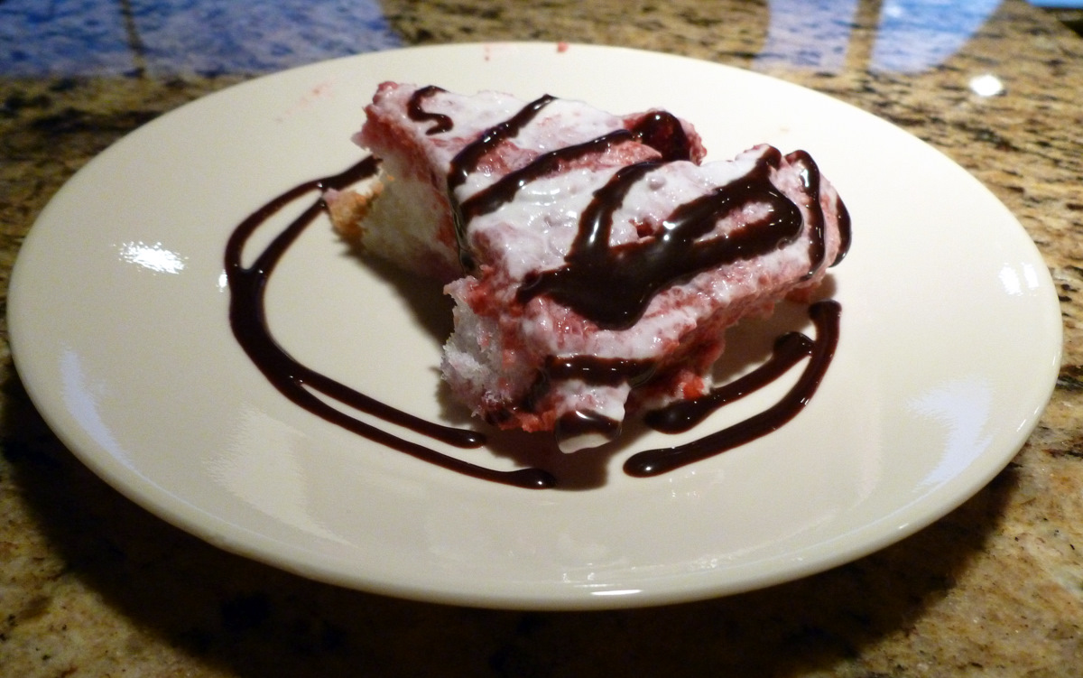
Marsha's Raspberry Chocolate Truffle.


Sunday, September 4th,  2011 - Secret Cove to Montague Harbor


In the morning, we slipped the dock lines and headed for Montague Harbor a 6-hour run across the Georgia Strait (aka Salish Sea).  The ocean was flat and winds were calm.  The sun shown.  We followed a Selene 43 for several miles and chatted with the owners.  Then cruised through Gabriola Passage with a 3-knot current push.  At last we anchored with the masses at Montague Harbour, a BC park on the south end of Galiano Island, one of the Gulf Islands.  Pat prepared a wonderful spicy jambalaya with fresh store bought prawns and Williebird's secret ingredients.  Pat's Chocolate Chip and ice cream helped tone down those Louisiana spices.
Merry Island Light Station in a flat calm ocean.

Gabriola Passage


Montague Harbour

Pat's prawn jambalaya. 

Chocolate Chip cake and ice cream.

Sunset over Montague Harbour.

 Monday. September 5th, 2011 - Montague Harbor to Ganges Harbour


It's just a 40-minute hop to Ganges Harbour.  We have fresh homemade cinnamon roll french toast from the local "bakery boat".  Then we burn off those carbs on a wilderness walk at camp Montague.  


Alex heads to the "boat bakery" (in background) for "boat" made cinnamon buns.  The bakery is an old ferry that has a commercial kitchen.  It's pretty much drive through these days:  drive your dinghy up and they bring out the goods to you.  It's quite popular here in the Gulf Islands.


Marsha sliced the fresh cinnamon buns and produced a delicious French toast. 

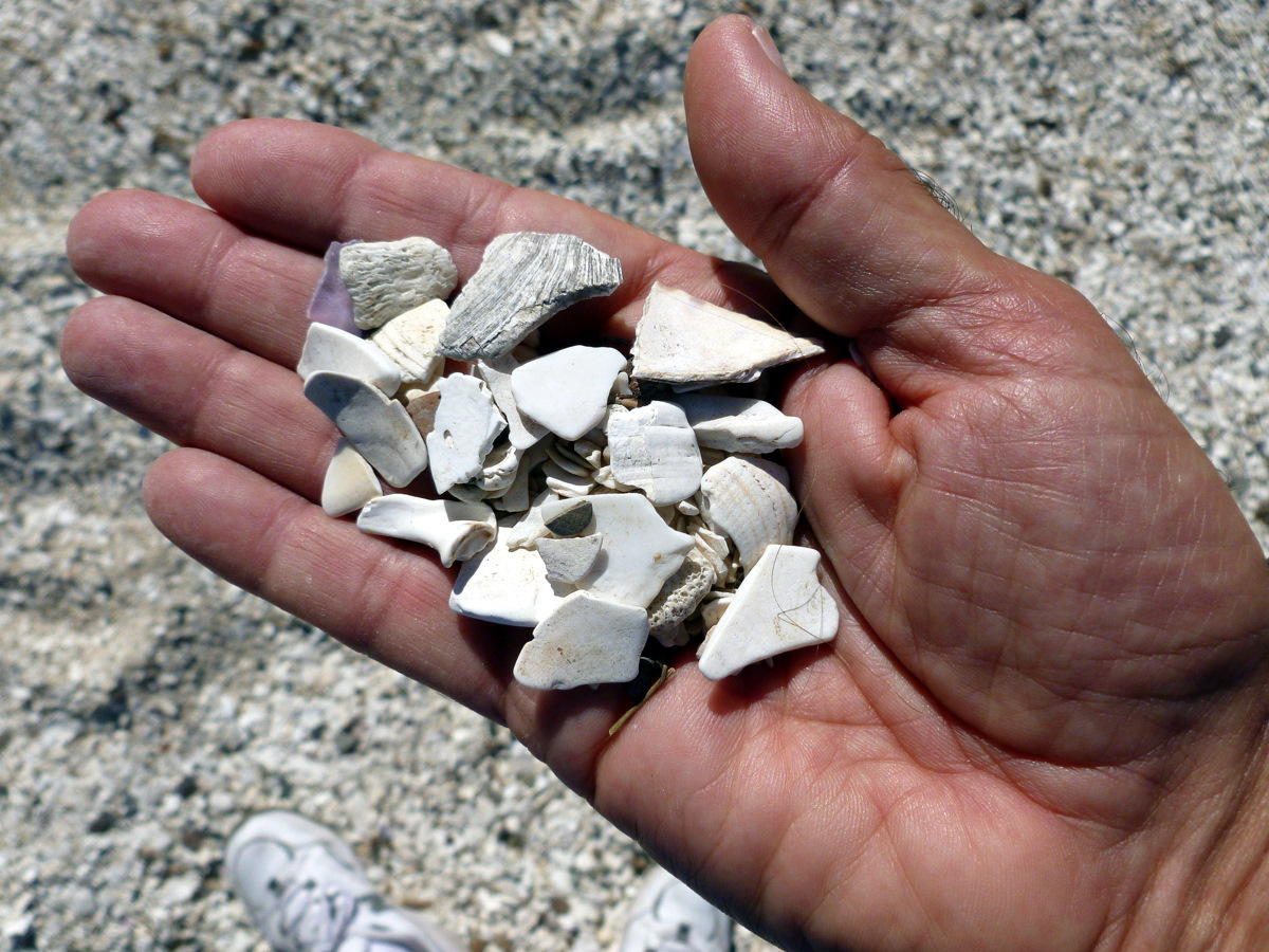
Our wilderness walk took us to the real "Shell Beach",  Billions and billions of broken clam, crab, oyster, abalone and other sea shells.  That other beach in SLO County with the same name should change it to "One Shell Beach"

Some trees in British Columbia grow horizontally.

After our walk we moved over to Ganges Harbour, an art, culture and bust island community.  Ganges is supposed to have the highest concentration of millionaires in all of BC.  We strolled the town and the girls sort of "shopped till they dropped".  The boys hung out at Moats Hardware.  Tomorrow we leave Canada and re-enter the USA.


Saltspring Island fire station: all volunteer.

Alex is booking it with "Cutting for Stone".

Marsha prepared a tasty lemon caper chicken just for lunch.  Can't wait for dinner!


Tuesday, September 6th, 2011 - Ganges Harbor, BC to Roche Harbor, WA


After Ganges it was the USA and Roche Harbor US Customs.  Every US customs experience is different.  It seems like the rules change each time.  It's kind of like city planning and building codes, except the changes are even more frequent.  This time the plants were a problem.  Our house plant, Wilson, has been on Wild Blue since 2005.  Lately US and even Canada Customs says Wilson is persona (planta?) non grata.  But each time he gets in after a lecture about plant diseases etc.  


The new thing this time was Washington registration tags.  Apparently the US Customs and Homeland Security is now acting on behalf of the Washington State Department of Revenue.  So the US Customs Agent is lecturing us about Washington rules. Of course we know the rules, and we also know he's way outside his jurisdiction, but we cant really tell him to f--k off because we want to get back home.  So we take his lecture like good students and play dumb, and even thank him for this information.  Some officials like to exert their power.  Whatever happened to power to the people!  Oh well.....


At Roche we get back to civilization and enjoy the many beautiful boats that line docks here.


Wednesday September 7th, 2011  - Roche Harbor to Friday Harbor


Friday Harbor really IS civilization. They have cars, busses, airplanes, ferries, a supermarket, hardware store and even a West Marine.  Plus there are a few great restaurants. Our favorite is Vinny's.  We dined out for a change and really enjoyed Vinny's.  


Thursday, September 8th, 2011 - Friday Harbor to Anacortes


Today we arrived at or dock here in Skyline Marina, Anacortes, WA.  It's good to be back to a town where we seem to spend more and more time.  Tonight we'll dine at wonderful Cameron's Restaurant.  This place is special but would seem to have more in common with Santa Monica or Brentwood, CA.  


Tomorrow everyone leaves while Alex stays to prep the boat for fall and winter cruising.  So until then, happy boating.

Sunday, September 11, 2011

#18 Port McNeill to Princess Louisa Inlet

Monday, August 29th, 2011 - Port McNeill to Port Neville
Over the weekend we relaxed then visited and enjoyed the company of Vera and Len from the Selene 53 Chatham II.  These Canadians cruise to Northern BC each summer and we seem to run into them about this time of year in Port McNeil.   Vera made sure to have a good supply of Sleeman's Honey Brown Ale for Alex and we enjoyed many cruising and Selene stories. 

On Monday morning the new Wild Blue crew arrived via Port hardy airport.  We borrowed the marina van and picked them up.  Most of the provisioning had been completed so only a few items were needed. After a quick trip to the Port McNeill market, we shoved off southbound at 1PM for Blind Channel, a long 6-hour run.  Our guests want to visit the Princess Louisa Inlet, which means we need to get south quickly in order get in and out of the Inlet.  PLI is 40 miles inland from Pender Harbour so we will need to put in several long cruise days early in this week, to allow time for the visit. of course as always, it depends on how far the weather lets us go.  Today's forecast calls for strong winds in Johnstone Strait.  We will go as far as comfort allows us!

Eastbound in sunny Johnstone Strait

Marsha and Ira Alpert our neighbors from San Luis Obispo are the new Wild Blue crew.  Ira is a retired hospital administrator who volunteers on several non-profit boards in our community. Marsha is retired form several businesses but, according to Ira, is still employed as a "consulting weather witch".  It seems that most everywhere Marsha travels, the weather improves.  After months of gray and rainy skies, we will put her talent to good use.  And with just a few hours cruising under our belts, the sun shines again.  Wow...what a talent! 
Pie in the sun for the Skipper.  After months of gray, overcast and rainy skies, it's time for a little Vitamin D.

Marsha's "weather witching" was working on the sun, but not on the wind which began to build as the afternoon wore on.  By 5PM a nasty chop punched into our eastbound travel.  We decided to anchor in Port Neville instead of continuing further.  There's always tomorrow.  By 6PM we were securely anchored in a blustery winds.

Port Neville is a convenient spot just off Johnstone Strait.


Port Neville Public Dock.  A great place to tie up, however as the tide fills and empties Port Neville Bay, the current across the float can be mighty.  We chose to anchor just around the corner further inside inside the Bay.

Tuesday, August 30th, 2011 - Port Neville to No Name Anchorage in Desolation Sound
This morning's forecast again calls for high winds in Johnstone Strait.  So instead of continuing, we decide to pull out of the Strait at Chancellor Channel and push through Greene Point Rapids, then Dent Rapids and finally Yuculta Rapids arriving in Desolation Sound for an anchorage.  For a slow boat like Wild Blue to traverse all three rapids in one leg, the "Rapid Trifecta", timing is essential.  The idea is to arrive at Greene Point with a manageable ebb current, then and hour or so later at Dent and Yuculta near slack or a minor flood current.  The problem is that we are 25 miles away from the first rapids.  So calculating using a conservative speed, we estimate a 4-hour run at 6.5 knots.  We should make it with time to spare leaving at 6:30AM.  We need to be at Greene Point by 10:30 to have a chance to cross all three rapids.


Killer Whale on the bow.

Once underway all is well until Current Passage.  Living up to it's name, we see our forward progress drop from 8 knots to 2 knots as a 6-knot ebb rolls through the Passage.  Obviously we won't make the first Rapids at this slow speed, but after 30 minutes of creeping between 2 and 3 knots, our turn into Chancellor Channel, and the speed over ground slowly begins to increase.  At last we make Green Point Rapids at 10:20, just 10 minutes off our estimates ETA.


Weather Witch Marsha has been doing her magic as the sun has been shining and the temps are warm.  She still needs to keep working on the winds.


Logging operations in Chancellor Channel.

Greene Point Rapids.

Dent Rapids.

Yuculta Rapids.
You know you've done a good job of calculating slack current when there's lots of traffic in the rapids at the same time.


By the early afternoon we're in Desolation Sound.  We pause just offshore from Squirrel Cove to get a wifi connection and our email.  Next we look around for an anchorage and eventually decide on a spot on the west side of Malaspina Inlet next to the Josephine Islands.  The cove has no name but gives us good protection form the expected building northwesterly winds.  


The chefs get active. After dinner it's a friendly game of Monopoly, and the Skipper has a bit too much property management luck (experience) tonight.  Hopefully he can take his winning approach to collecting the rents in real life!


Wednesday, August 31st, 2011 - No Name Anchorage to Pender Harbour


Today we had a leisurely motor to Pender Harbor in sunny skies, warm temps and little wind.  Marsha's magic was working.  In general it was a pretty dull cruise but with lots of boat traffic.  We found moorage at the Pender Public Dock which is close to the Marketplace, a full-sized supermarket.  Provisioning is in our future today.


Tug and Tow.


Big boat wake.


Arriving in Pender Harbour.

Our Pender Harbour moorage sets us up to enter Princess Louisa Inlet tomorrow.  The Inlet has Malibu Rapids in front of it and crossing the rapids needs to be near slack current.  The current reaches over 12 knots on spring tides.  As Labor Day Weekend approaches, the Inlet will fill up with boats and securing a vacant anchorage spot could become an issue.  So we decide to cross the rapids and enter the Inlet at the 9:45AM slack tide.  From Pender, it's about 36 miles to the rapids, a 4.5 hour motor if no adverse current.  Giving us a little wiggle room, we decide to leave at 4:30AM in the dark.  But that's for tomorrow.  It's time for dessert!


Fresh blueberries with ice cream and chocolate syrup.


Thursday, September 1st, 2011 - Pender Harbour to Princess Louisa Inlet


At 4:30AM it's black dark.  Silently as possible we back out of our dock as to not awaken the snoring, and then try to adjust our vision to the black.  The chart-plotter guides us and the radar keeps us from bumping the rocks.  Just outside the Harbour we are passed by small boat, but we only see its running lights.  Pat, Ira and Marsha man the foredeck squinting to see logs, boats or rocks.  Running in the dark builds tension which is relieved when dawn finally arrives.  By that time we are 9 miles up Agamemnon Channel.


The suns rises over Agamemnon Channel.

We arrive at Malibu Rapids at 10:30 some 45 minutes late, but even though the chart warning reads "Extremely Hazardous Currents and Eddies", all is well with only a 2.5 knot current against us as we enter.  Once inside we slow to minimize our wake and cruise the final 5 miles to the head of the Inlet where we plan to anchor.  After locating our favorite anchor site and its associated submerged stern tie hook just north of the Falls,  we drop the hook.  We won't be able to reach the stern tie hook until low tide this afternoon.  Then we will thread a line through the eye and back to the boat.  Being the start of Labor Day weekend, we are surprised that only 15 boats or so have entered the Inlet.  The weather is overcast again, so I guess "weather witch" Marsha has not been focusing on the sun.

Entering PLI via Malibu Rapids


Approaching the head of Princess Louisa Inlet.


This weeks guest crew is Marsha and Ira Alpert of San Luis Obispo. Here they pose just in front of Chatterbox Falls.


Wild Blue on the hook in PLI.  Waiting for low tide to hook up the stern tie hook which is submerged at high tide.

The Chatterbox Falls in Princess Louisa Inlet.


Friday, September 2nd, 2011 - Princess Louisa Inlet


At last the sun is out again.  We're spending an extra day here in PLI enjoying Yosemite Park of the North.  What a relaxing place!


Marsha and Alex go kayaking.


Looking northwest up PLI.


Sunday, August 28, 2011

#17 Lewall Inlet, Frypan Bay, Sullivan Bay, Turnbull Cove and Port McNeill.

Tuesday, August 23, 2011: Lewall Inlet, a Pruth Wifi stop, to Frypan Bay

Although still gloomy, the rain has stopped.  Today we will follow the Maritime to Pruth Bay on Calvert Island.  Rob and Donna want to visit the Hakai Institute.  The Wild Blue crew wants to use the Institute's open wifi signal to get the email.  It's about 5 miles from Lewall Inlet just across the Hakai Passage.

Once there, we hover near the wifi signal and later leave Maritime anchored.  We learn from email that our friends on Z-Worthy, another Selene, were behind us in Shearwater two days ago.  So today they should be close if they haven't already passed us.  We'll keep a lookout for them.

Once out in Fitz Hugh Sound going south, we give the Z-Worthy a call on the VHF. No answer.

We want to end the day in a secure anchorage near Rivers Inlet such that we will be about 4 hours or so from Cape Caution. We need to cross Queen Charlotte Sound which is an exposed ocean run. The nearest anchorage probably is Fury Cove on Penrose Island however it is exposed to southerly winds.  We decide upon one of the Frypan anchorages: either Big Frypan or Frypan.  The names probably come from their shape.  Like Alaska, these anchorages have a handle which is a narrow entrance.  The bays are round, much like a frying pan. Frypan is more popular because it is not a deep anchorage.

We arrived at Frypan and anchored as the lone boat then took the tender out exploring local lagoons.  Back in the Bay, the Grocery Boy of Anacortes had anchored.  This charter boat goes to Alaska each year.  We visited on the Grocery Boy and talked about the fishing.  THat day Rivers Inlet had yielded them multiple salmon and a huge halibut.  The charter crew was quite happy.  They will fish again tomorrow.  We plan to round Cape Caution.

By 6PM about 7 boats had anchored inside "our" bay. Thirty minutes later we hear "Wild Blue, Wild Blue, this is Z-Worthy" calling on the VHF.  Seems they found us via AIS and were heading for Frypan.  We invited them to side-tie to Wild Blue and to join us for dinner.  Ron and Bonny told scary stories of high winds and nasty seas on their run down northern British Columbia.  They seemed too happy to be in a quiet anchorage.

 
Entering Frypan Bay


Lagoon has it's own ecosystem.

Bill examines this lagoon's flora and fawna.

Wednesday, August 24, 2011: Frypan Bay, Cape Caution to Sullivan Bay

Any Cape Caution rounding starts with the 4AM BC Marine Forecast for Queen Charlotte Sound.  Information on the current conditions at the West Sea Otter Buoy and Egg Island Lighthouse is also desirable.  Alex monitored the weather broadcast.  Our rule of thumb for rounding is: "a Queen Charlotte Sound wind forecast less than 20 knots and a sea condition report at West Sea Otter Buoy less than 1 meter". The seas were already 2 meters at 5AM but the Egg Island Lighthouse reported "Seas rippled with a low northwesterly swell".  So at first light, the crew detached Z-Worthy from her side-tie, secured the tender to the boat deck, raised the anchor, and headed south into the Sound.  The winds were less than 10 knots but the seas occasionally reached 2 meters (6 feet). Thankfully these larger seas were well-spaced apart so that the rolling motion was mostly dampened by the boats active stabilizer fins.

We took the inside route, just off the coastline, threading our way between the many rocks and reefs that litter the Cape area, but that also provide smoother seas close off the beach.  We stayed behind Egg and Table Islands with good sea conditions.  Z-Worthy and another yacht followed close behind.  By 10AM we rounded Cape Caution as the winds and seas slowly decreased to nothing, and a fog enveloped the boats.  We passed a few northbound boats within 1/4 mile without seeing them but the radar and AIS allowed us to pass without collisions.  We turned into Wells Passage as the fog lifted and tied to the dock at Sullivan Bay around 2PM in front of Three Wishes another Selene 53.  Neil and Nancy invited the crews to a dinner of Greek fair at the floating town's restaurant. The sun came out near the end of the day.

Selenes line the Sullivan Bay Dock: Z-Worthy, Wild Blue, and Three Wishes.

Our first sunset with real sunlight in 5 days!

Thursday, August 25, 2011:  Sullivan Bay to Turnbull Cove

Only 40 minutes away, Turnbull Cove is a great place to enjoy the sunshine.  Along the way we dropped the prawn traps in 280 feet outside the entrance.  Inside the cove we started the crab traps soaking too.  Soon after anchoring and side-tying with Z-Worthy, we visited the Nepah Lagoon.  The entrance to this 4-mile by 1/2 mile body of water is restricted to 3 feet at low water and is only 50 feet wide so that the current races by at 10 knots, unless you enter at slack.  We did so about 30 minutes after slack and the dinghy needed an engine RPM boast.  The lagoon is BIG.  We motored to the end searching for salmon rivers.  Great scenery gave way to the need to exit before the entrance rapids escalated.  Upon exit the water fell like a water fall, albeit only a tiny one.  We squirted out without incident.

Approaching Turnbull Cove

It's Karen's birthday.  No worries, her young age will not be divulged.  Tonight's dining venue is on the cleared boat deck of the Wild Blue in brilliant sunshine.  The menu is impressive:

Karen's Birthday Epicurean Dinner
Happy Hour: Wiser's Whiskey cocktails with Z-Worthy's fresh sushi
Main Course: Wild White King and Coho Salmon bbq'd on cedar plank, Willie-Bird bbq'd duck breast, wild rice and vegetable medley
Wine:  2004 Opus One
Dessert: Homemade Key Lime pie with fresh-whipped cream.


At last summer has arrived in the Pacific Northwest!


Dining at Wild Blue Skylounge.

Wild Cedar Plank Salmon and BBQ duck breast.

Bonny, Pat and Karen.

Happy Birthday Karen.


Friday, August 26, 2011:  Turnbull Cove to Port McNeill

Port McNeill is the destination of choice for exchanging crew. Lately we secure moorage at the Port McNeill Fuel Dock and Marina as opposed to the city run dock.  Besides great accommodation and 50-amp power, they provide free use of a van for picking up or dropping off crew at the Port Hardy Airport.  

It's a short 3-hour tour of Wells Passage and Queen Charlotte Strait to get to McNeill.  The water was flat calm and the Strait displayed little wind.  You could see small groups of Dall's Porpoise breaking the surface more than a mile away.  As we approached Ledge Point just outside McNeill, many sports-fishers were trolling close ashore. Later we learned that the Coho and Silver Salmon are biting big-time in the early mornings.

On the dock we see the a pretty green Selene 53 named Chatham II.  Vera and Len are Canadians who have been cruising BC waters all their lives on sailboats and the last several years on their Selene.  They have a cool fireplace inside their saloon.  We'll be sure to join them to swap a few sea stories.

Karen and Bill, the Wild Blue crew this past week or so, leave for San Luis Obispo tomorrow.  It's been a fun time with the easy going Almas'.  Monday a new crew arrives.  Pat and Alex will take a few days to wind down.

Evviva arrives in Port McNeill.  This 160-foot Westport super-yacht is owned by the guy that built 4000 Bayliner Yachts for years and then sold out to Brunswick Corp.  Later he re-entered the boat building business with Westport yachts an "economically priced" super-yacht line.  This one sells for an economy minded $30 million.  Contrary to the video narrator, we didn't get an invite to dinner aboard Evviva.


Saturday, August 27, 2011

#16 Bella Coola, Namu to Lewall Inlet

Sunday, August 21, 2011: Bella Coola to Rocky Inlet (Namu)

Rain and southeast winds are predicted today.  The Wild Blue and Maritime will slowly cruise westward, down Burke Channel, towards the building winds and rain.  There are several places to duck into if it gets nasty including: Cathredral Point anchorage, Fougner Bay, Namu or Rocky Inlet behind Namu.  So off we go examining the various creeks and rivers, which because of the heavy rains, are all flowing like big rivers.  We are looking for salmon amassing near these water mouths.

Maritime holds her course.

We fish our way along and all goes well, for the weather, but not the fishing.  At Cathedral Point, about 30 miles southwest of Bella Coola, winds are light, rain is heavy and we continue. 20 miles later, the winds are building with gusts over 20 knots so we decide on Fougner Bay.  This Bay is small but nicely preotected and upon close inspection, we find two boats already anchored there.  We continue and as we turn left into Fitz Hugh sound, the winds are gusting in the upper 20's and the seas are punchy.  The Namu dock looks to be too exposed to these southerly winds, so we sneak back into Rock Inlet, just behind Namu and anchor in calm waters with a few other boats.  It's a good place to be as the winds are less than 10 knots.

Wild Blue battles the building seas and driving rain. (Rob Bonner photo)

Namu was once a busy fish canning town.  The killer whale that was caught in a fisherman's net near the town assumed it's name.  Namu now  serves as a overnight spot for visiting pleasure craft.

Entering Rock Inlet

Rock Inlet after the wind dies.  The top is live, the bottom is a reflection.

This is not a  Rorschach  diagram.

Pat's homemade tabbouleh, Karen's Teryaki salmon, and seasoned potatoes made us forget the rainy weather..

Monday, August 22, 2011: Rocky Inlet to Lewall Inlet

The storm has passed and just spotty light rain remains.  Today we'll cross Fitz Hugh "Sound", which really seems more like a "Strait".  On the way we'll fish just outside Namu, then the Nalau Pass area.  The plan is to stay inside well-protected Lewall Inlet for the night, just in case.

Our Route for the next few days.

Exiting Rock Inlet

The ocean is quite calm and once trolling, it's easy to see our flashers down to 20 feet deep.  We troll at 35 and 50 feet using Apex lures: Alex's shiny bright Hot Shot, and Bill's dull green Apex.  It's a dull green kind of day and Bill begins landing fish.  A small King, a big Coho, another King, all this as Alex watches.  Finally the skipper gets a bite and lands a King, but it didn't have the fight to detach from the down-rigger! Oh well.

After a short day of cruising-fishing, we squeeze through the narrow entrance to Lewall Inlet on Stirling Island and anchor for the night.  We invited Rob and Donna for dinner aboard, and Donna brought some yummy crab artichoke dip.   We served Pat's homemade meatballs with Karen's tasty Italian sauce over linguine.   All crew survived a dessert of homemade brownies and ice cream.  We slept good!

Veteran Wild Blue crew Bill Almas shows how easily it is to catch a salmon.  This Coho is around 30 inches or so.


Today's haul off Namu and inside Nalau Pass area after 90 minutes of trolling.  Bill caught three fish and chopped the head off Alex's fish.  Note how small Alex's fish looks.

Entering Lewall Inlet on Stirling Island